
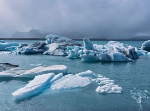
Why Greenland Is Called Green But Iceland Is Not Icy
By Trivia Daily, Geography Desk — Published September 14, 2026
Table of Contents
- Key Takeaways
- Why Greenland Called Green: The Viking Marketing Campaign
- Iceland’s Icy Name and Temperate Reality
- Comparing the Two Islands: Geography and Climate
- The Role of Medieval Climate in Settlement Patterns
- Modern Geography and Scientific Importance
- Frequently Asked Questions
Few geographic names spark as much confusion as Greenland and Iceland. The world’s largest island bears a verdant name despite being covered by a massive ice sheet, while Iceland, positioned in the frigid North Atlantic, sounds inhospitable yet boasts relatively mild temperatures and lush valleys. Why is Greenland called green when it’s predominantly white with ice? The answer involves Viking marketing tactics, medieval climate patterns, and a dash of ironic geography that has puzzled travelers and map enthusiasts for over a millennium.
The naming paradox traces back to Norse explorers in the late 10th century. Erik the Red, a Viking outcast banished from Iceland around 982 CE, sailed westward and discovered the massive landmass we now call Greenland. Despite finding an island roughly 80 percent covered by ice, Erik deliberately chose the name “Greenland” to attract settlers from Iceland and Norway. The coastal areas he explored did feature green vegetation during summer months, particularly in the southwestern fjords, but the name was primarily a promotional strategy. Iceland’s name, conversely, came from earlier Norse explorer Flóki Vilgerðarson, who reportedly encountered sea ice during an unusually harsh winter and named the island accordingly, despite its relatively temperate climate compared to other Arctic places.
Key Takeaways
- Greenland received its misleading name from Viking Erik the Red around 982 CE as a deliberate marketing strategy to attract settlers, despite approximately 80 percent of the island being covered by an ice sheet.
- Iceland was named by Norse explorer Flóki Vilgerðarson after encountering sea ice during an unusually cold winter, even though the island features relatively mild temperatures due to the Gulf Stream’s influence.
- The Medieval Warm Period (roughly 950–1250 CE) made Greenland’s coastal regions more hospitable during initial Norse settlement, supporting the “green” description to some degree.
- Today, Iceland has about 11 percent glacial coverage while Greenland’s ice sheet covers roughly 1.7 million square kilometers, making it the world’s second-largest ice body after Antarctica.
- Both countries occupy strategic positions in the North Atlantic Ocean between North America and Europe, playing crucial roles in understanding climate change and Arctic geography.
Why Greenland Called Green: The Viking Marketing Campaign
Erik the Red wasn’t just exploring when he discovered Greenland. He was exiled. After being banished from Iceland for manslaughter, this Norse adventurer needed a fresh start and a compelling reason for others to join him in a remote, challenging environment. The name “Greenland” served as medieval advertising.
The southwestern coast of Greenland, where Erik established settlements, does support vegetation. During summer, grasses, wildflowers, and low shrubs blanket the ice-free coastal strips. These areas, particularly around present-day Qaqortoq and the ruins of Erik’s settlement at Brattahlíð, offered grazing land for sheep and cattle. The Medieval Warm Period provided slightly milder conditions than today’s climate, making agriculture marginally more viable. Erik’s naming choice wasn’t entirely dishonest—it simply emphasized the best features while downplaying the massive ice sheet dominating the interior.
The strategy worked. According to medieval Icelandic sagas, Erik returned to Iceland after exploring Greenland and successfully recruited colonists. The Norse established two main settlements that persisted for roughly 500 years before mysteriously disappearing in the 15th century, likely due to cooling temperatures, resource depletion, and isolation.
Iceland’s Icy Name and Temperate Reality
Iceland’s naming story begins earlier, around 870 CE. The Norse explorer Flóki Vilgerðarson sailed to the island with livestock and supplies, intending to settle. After arriving, he climbed a mountain and saw a fjord filled with sea ice, which inspired the name “Iceland.” His negative experience and harsh first winter led him to return to Norway with unfavorable reports.
Despite this chilly introduction, Iceland enjoys a surprisingly mild climate for its latitude. The island sits just south of the Arctic Circle, yet benefits enormously from the North Atlantic Current, an extension of the Gulf Stream. This warm ocean current keeps temperatures moderate year-round. Reykjavík, the capital, averages around 0°C in January and 13°C in July—cold but far from the extreme Arctic conditions the name suggests.
Iceland does contain glaciers covering about 11 percent of its landmass, including Vatnajökull, Europe’s largest glacier by volume. Yet the island also features geothermal hot springs, active volcanoes, lush green valleys, and extensive grasslands that support agriculture and livestock farming. The country produces greenhouse vegetables using geothermal energy and maintains a thriving agricultural sector despite its northern location.
Comparing the Two Islands: Geography and Climate
| Feature | Greenland | Iceland |
|---|---|---|
| Total Area | Approximately 2.16 million km² | Approximately 103,000 km² |
| Ice Coverage | Roughly 80% (ice sheet) | Roughly 11% (glaciers) |
| Population | Around 56,000 | Around 370,000 |
| Capital Winter Temperature | Nuuk: -8°C average (January) | Reykjavík: 0°C average (January) |
| Political Status | Autonomous territory of Denmark | Independent republic |
The climate differences stem from ocean currents and latitude. While both islands sit in the North Atlantic, Iceland benefits from warmer waters flowing from the south. Greenland’s massive ice sheet creates its own weather patterns, generating cold air that keeps temperatures low even in summer along much of the coast.
The Role of Medieval Climate in Settlement Patterns
The Medieval Warm Period played a crucial role in making both islands habitable for Norse settlers. During this time, Atlantic waters warmed, sea ice retreated, and growing seasons lengthened across Northern Europe and the Arctic. Greenland’s coastal areas became more hospitable, supporting the dairy farming and sheep herding that sustained Norse communities for centuries.
When temperatures cooled during the Little Ice Age (roughly 1300–1850 CE), conditions deteriorated dramatically. Sea ice expanded, making navigation treacherous and isolating Greenland’s settlements. Farming became increasingly difficult. The Norse colonies in Greenland disappeared by the late 15th century, while Iceland’s population survived, though they faced severe hardships including volcanic eruptions and plague.
These climate shifts demonstrate how even small temperature changes affect Arctic and sub-Arctic regions. Today, as global temperatures rise, Greenland’s ice sheet is melting at accelerating rates, revealing landscapes unseen for millennia and raising concerns about sea level rise worldwide.
Modern Geography and Scientific Importance
Both countries now serve as natural laboratories for understanding Earth’s climate systems. Greenland’s ice sheet contains ice cores that preserve atmospheric records spanning hundreds of thousands of years, providing invaluable data about past climate conditions. Scientists drill deep into the ice, extracting cylinders that reveal ancient temperatures, atmospheric composition, and volcanic activity.
Iceland’s position atop the Mid-Atlantic Ridge makes it a geological hotspot. The island literally straddles two tectonic plates—the North American and Eurasian—which are slowly drifting apart. This unique geography creates Iceland’s famous volcanic activity and geothermal features, attracting researchers studying plate tectonics, volcanism, and renewable energy.
The maps we use today clearly show the irony of these names. Satellite imagery reveals Greenland’s massive white ice sheet dominating the landscape, while Iceland appears relatively green and ice-free by comparison. Yet the names persist, a thousand-year-old reminder of Viking exploration, medieval climate conditions, and the power of effective branding.
Frequently Asked Questions
Is any part of Greenland actually green?
Yes, the coastal regions of southern and southwestern Greenland support vegetation including grasses, wildflowers, and low shrubs during summer months. These ice-free areas constitute about 20 percent of the landmass and provided grazing land for Norse settlers’ livestock.
Why didn’t Iceland freeze over if it was named for ice?
The North Atlantic Current brings warm water from the Gulf Stream to Iceland, keeping temperatures relatively mild despite the northern latitude. The explorer who named Iceland encountered sea ice during an unusually harsh winter, but this isn’t typical of the island’s overall climate.
Could the names have been deliberately switched to confuse enemies?
This popular theory lacks historical evidence. The names arose from different explorers at different times based on their individual experiences. Erik the Red’s promotional naming of Greenland is well-documented in Icelandic sagas, while Iceland’s name came from an earlier explorer’s unfortunate encounter with sea ice.
Which island is colder year-round?
Greenland is significantly colder overall, particularly in the interior where the massive ice sheet generates its own frigid climate. Iceland’s coastal areas and valleys experience milder temperatures due to ocean current influences, making it more habitable despite being located farther north than parts of Greenland.
The next time you glance at a world map and spot these two North Atlantic islands, remember that their names tell stories of Viking ambition, medieval climate, and geographic irony. Erik the Red’s marketing genius gave us one of geography’s most enduring puzzles—a frozen island called green and a relatively temperate one named for ice. These misnomers continue to spark curiosity and remind us that place names often reveal as much about human perception and history as they do about the actual landscapes they describe.