
Why Mount Everest Grows About Four Millimeters Each Year
By Trivia Daily, Geography Desk — Published September 24, 2026
Table of Contents
- Key Takeaways
- The Collision That Created the Roof of the World
- How Scientists Measure Mountain Growth
- Growth Versus Erosion: The Mountain’s Battle
- Earthquakes and Sudden Changes
- A Global Perspective on Moving Continents
- Frequently Asked Questions
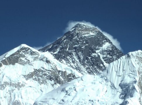
Mount Everest, the world’s tallest peak above sea level, isn’t finished growing. Every year, the mountain gains roughly four millimeters in height—about the thickness of a pencil eraser. This slow but relentless growth stems from the same geological forces that created the Himalayas millions of years ago, forces that continue to push the Earth’s crust skyward even today. Understanding why Mount Everest grows reveals the dynamic nature of our planet’s geography, where continents collide and mountains rise in geological slow motion.
The mountain sits on the border between Nepal and Tibet, straddling two countries whose landscapes have been shaped by one of the most dramatic tectonic events on Earth. What makes this growth particularly fascinating is that it’s happening right now, beneath our feet, reshaping the maps and landmarks we often think of as permanent fixtures of the world.
Key Takeaways
- Mount Everest grows approximately four millimeters per year due to ongoing tectonic plate collision between the Indian and Eurasian plates.
- The Himalayas began forming about 50 million years ago when the Indian subcontinent crashed into Asia, one of the most significant geographical events in Earth’s history.
- The Indian plate continues to move northward at roughly 40 to 50 millimeters annually, sustaining the mountain-building process across the region.
- Earthquakes in the region can cause sudden height changes—the 2015 Nepal earthquake actually reduced Everest’s height by about 2.5 centimeters temporarily.
- Mount Everest’s current height is measured at 8,848.86 meters (29,031.7 feet), a measurement jointly announced by Nepal and China in 2020.
- The mountain’s growth rate varies slightly over time and isn’t perfectly uniform due to erosion, earthquakes, and other geological factors.
The Collision That Created the Roof of the World
The story of why Mount Everest grows begins tens of millions of years ago with a continental collision of epic proportions. The Indian subcontinent, once a separate landmass far to the south, drifted northward across ancient oceans on its tectonic plate. When it finally collided with the Eurasian plate around 50 million years ago, neither plate could slide beneath the other—both were made of relatively light continental crust that refused to sink.
Instead, the crust crumpled and buckled upward. Think of pushing two pieces of paper together on a table: they fold and rise rather than passing through each other. This process created the Himalayas, the youngest and tallest mountain range on Earth. The entire region, from the peaks of Everest to the Tibetan Plateau, represents the world’s most dramatic example of continental collision.
The Indian plate hasn’t stopped moving. It continues its northward journey at a rate of about 40 to 50 millimeters each year, roughly the speed at which human fingernails grow. This persistent pressure keeps pushing the Himalayas upward, adding height to Everest and its neighboring peaks year after year.
How Scientists Measure Mountain Growth
Measuring tiny annual changes in a mountain nearly nine kilometers tall requires sophisticated technology. Modern surveying techniques combine GPS satellites, ground-based measurements, and satellite radar to track Everest’s height with millimeter precision. These methods can detect not only the mountain’s overall elevation but also subtle movements in the surrounding landscape.
Researchers place GPS receivers on the mountain and surrounding areas, which communicate with satellites orbiting overhead. By tracking these signals over months and years, scientists can calculate exactly how much the ground has moved. Satellite-based radar interferometry provides another layer of data, comparing radar images taken at different times to detect ground deformation.
The measurement itself is more complex than it might seem. Scientists must account for the geoid—the shape of Earth’s gravitational field—and decide whether to measure to the rock surface or include the snow and ice cap that crowns the summit. The 2020 joint measurement by Nepal and China used both traditional surveying and modern satellite data to arrive at the currently accepted height.
Growth Versus Erosion: The Mountain’s Battle
While tectonic forces push Everest upward, other natural processes work to tear it down. Wind, ice, and extreme temperature fluctuations constantly erode the mountain’s surface. Glaciers carve away at its flanks, and rockfalls strip material from its faces. The mountain exists in a constant tug-of-war between uplift and erosion.
Despite these erosive forces, uplift wins. The net growth of about four millimeters per year represents the difference between the tectonic push upward and the erosive forces pulling downward. In some places across the Himalayas, erosion nearly matches uplift, but Everest’s position in the range means tectonic forces maintain the upper hand.
Climate plays a role too. As global temperatures change, glacial patterns shift, potentially altering erosion rates. Heavier monsoons can accelerate weathering, while changes in snow and ice cover affect how quickly exposed rock breaks down. These factors make predicting the mountain’s exact future height more complicated than simply multiplying four millimeters by the number of years.
Earthquakes and Sudden Changes
While Everest’s general trend is upward, the journey isn’t always smooth. Major earthquakes can cause sudden, dramatic changes to the mountain’s height and position. The devastating 2015 earthquake in Nepal, which measured 7.8 on the Richter scale, actually lowered parts of the mountain by a few centimeters and shifted it horizontally by several centimeters to the southwest.
These seismic events reflect the immense stress building up as the Indian plate continues ramming into Eurasia. The collision doesn’t happen smoothly—instead, pressure builds along fault lines until the rock suddenly breaks and shifts, releasing energy in the form of earthquakes. Each major quake redistributes stress throughout the region, temporarily altering the landscape before the steady tectonic creep resumes.
| Mountain | Height (meters) | Location | Annual Growth Rate |
|---|---|---|---|
| Mount Everest | 8,848.86 | Nepal/Tibet border | ~4 mm/year |
| K2 | 8,611 | Pakistan/China border | ~3-4 mm/year |
| Kangchenjunga | 8,586 | Nepal/India border | ~3-4 mm/year |
| Nanga Parbat | 8,126 | Pakistan | ~7 mm/year |
A Global Perspective on Moving Continents
Everest’s growth is part of a larger planetary story. Tectonic plates constantly reshape the world’s geography, creating new oceans, closing old ones, and building mountain ranges across continents. The same forces that push up the Himalayas also drive the Andes upward in South America, where the Nazca plate dives beneath the South American plate.
The Mediterranean Sea is slowly closing as Africa moves northward toward Europe. Millions of years from now, it may become a mountain range rivaling the Himalayas. The Atlantic Ocean, meanwhile, widens by a few centimeters each year as plates pull apart along the Mid-Atlantic Ridge. These processes remind us that the maps we use today represent just one snapshot in Earth’s ongoing transformation.
Understanding these movements helps scientists predict earthquake risks, track climate patterns, and piece together Earth’s deep history. The rocks at Everest’s summit contain fossilized marine creatures from ancient seas—evidence that this peak, now the highest place on Earth, once lay beneath ocean waters before tectonic forces lifted it skyward.
Frequently Asked Questions
Will Mount Everest ever stop growing?
Eventually, yes. When the Indian plate’s northward movement slows or stops, or when erosion finally matches the rate of tectonic uplift, Everest will stop growing and may even begin to shrink. This process will take millions of years.
Is Mount Everest the fastest-growing mountain?
No. Nanga Parbat in Pakistan grows at roughly seven millimeters per year, making it one of the fastest-rising peaks in the world. Other Himalayan mountains also experience varying growth rates depending on their specific tectonic settings.
Does Everest’s growth affect climbing routes?
The four-millimeter annual growth is far too small to impact climbing routes in any noticeable way. However, earthquakes and glacial melting—which happen on much faster timescales—do change routes and create new hazards for climbers.
How do we know the Himalayas formed 50 million years ago?
Scientists date the collision by studying rock formations, analyzing magnetic signatures locked in minerals, and examining fossils. The geological evidence from both the Indian and Eurasian plates converges on a timeline beginning roughly 50 million years ago.
Every year, as Everest adds another four millimeters to its already staggering height, it serves as a monument to the restless planet beneath our feet. The mountain’s slow ascent reminds us that even Earth’s most permanent-seeming landmarks are really works in progress, still being written by forces that dwarf human timescales.