


⏱️ 6 min read
When venturing into the wilderness or spending time outdoors, the ability to recognize impending severe weather can mean the difference between safety and disaster. Nature provides numerous warning signals before a storm arrives, and understanding these indicators allows for adequate preparation and potentially life-saving decisions. By learning to read the sky, observe animal behavior, and detect atmospheric changes, anyone can develop the skills necessary to anticipate dangerous weather conditions before they strike.
Understanding Nature's Warning System
The atmosphere telegraphs its intentions through various observable phenomena. These signals often appear hours before the first raindrop falls, giving observant individuals crucial time to seek shelter, secure equipment, or alter travel plans. The following indicators have been recognized by meteorologists, sailors, and outdoor experts for generations as reliable predictors of incoming storms.
1. Rapidly Falling Barometric Pressure
One of the most reliable indicators of approaching severe weather is a sudden drop in barometric pressure. While most people don't carry barometers, the effects of falling pressure manifest in noticeable ways. Many individuals experience joint pain or headaches as pressure decreases. If a barometer or weather instrument is available, a drop of more than 0.02 inches of mercury per hour strongly suggests that a storm system is approaching within the next 12 to 24 hours. The faster the pressure falls, the more intense the approaching weather system is likely to be.
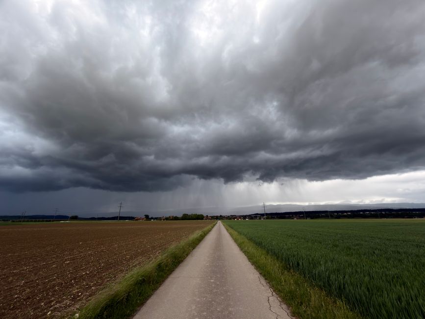
2. Distinctive Cloud Formations and Transformations
Cloud patterns serve as one of nature's most visible warning systems. The appearance of towering cumulonimbus clouds with anvil-shaped tops indicates powerful updrafts and the potential for severe thunderstorms. A progression from high, wispy cirrus clouds to lower, thicker cirrostratus, followed by dark nimbostratus clouds, typically signals an approaching frontal system. Additionally, mammatus clouds—pouches that hang beneath the base of a cloud—often appear after the worst of a storm has passed but can indicate extremely turbulent conditions. A mackerel sky, featuring rows of altocumulus clouds resembling fish scales, traditionally warns that rain will arrive within 24 hours.
3. Sudden Wind Direction Changes
Shifts in wind direction frequently precede storm systems as different air masses collide. In the Northern Hemisphere, winds that veer (shift clockwise) often indicate an approaching warm front, while winds that back (shift counterclockwise) can signal a cold front. A sudden calm after steady winds, known as the "calm before the storm," occurs when an approaching low-pressure system temporarily neutralizes prevailing winds. Pay particular attention to gusty, erratic winds that change direction frequently, as these suggest atmospheric instability and possible severe weather.
4. Unusual Animal and Insect Activity
Animals possess remarkable sensitivity to atmospheric changes and often alter their behavior before storms arrive. Birds typically fly lower than normal as falling air pressure affects their ears, and they may cease singing and seek shelter. Cows frequently lie down in fields before rain arrives, and livestock generally becomes restless. Insects, particularly flies and mosquitoes, become more aggressive and tend to swarm. Ants have been observed working frantically to reinforce their colonies, while bees return to their hives earlier than usual. Observing these behavioral changes in multiple species simultaneously provides strong evidence of approaching weather systems.
5. The Distinctive Smell of Approaching Rain
The human nose can detect an approaching storm through petrichor, the earthy scent produced when rain falls on dry soil. This aroma results from oils released by plants during dry periods and compounds produced by soil-dwelling bacteria. Additionally, ozone carried downward by storm downdrafts creates a sharp, clean smell often described as similar to chlorine. When these scents become noticeable, particularly in combination with other signs, precipitation is often less than an hour away.
6. Increasing Humidity and Temperature Changes
Rising humidity levels indicate that moisture-laden air is moving into the area, a prerequisite for storm formation. This manifests as a sticky, oppressive feeling, increased sweating, and the formation of dew or condensation on surfaces. Before cold fronts, a noticeable temperature drop may occur within minutes, sometimes accompanied by a visible wall of cooler air. Conversely, unusual warmth and humidity ahead of a front create the instability necessary for severe thunderstorms and tornadoes.
7. Distant Thunder and Lightning Activity
Thunder can be heard from approximately 10 miles away under ideal conditions, providing significant advance warning. When thunder becomes audible, the storm is close enough to warrant immediate preparation for taking shelter. Lightning visible on the horizon, even without audible thunder, indicates storm activity within 20 miles. The "30-30 rule" provides crucial guidance: if the time between seeing lightning and hearing thunder is 30 seconds or less (indicating the storm is within 6 miles), seek shelter immediately and remain there for 30 minutes after the last thunder is heard.
8. Morning Red Sky Phenomenon
The ancient saying "red sky at night, sailor's delight; red sky in morning, sailor's warning" holds meteorological validity. A red sky at sunrise indicates that a high-pressure system with dry air has already passed to the east, while moisture-bearing clouds approach from the west, illuminated by the rising sun. This optical phenomenon reliably predicts deteriorating weather conditions within 12 to 24 hours in mid-latitude regions where weather systems typically move from west to east.
9. Halo Around the Sun or Moon
A luminous ring or halo encircling the sun or moon occurs when light refracts through ice crystals in high cirrostratus clouds. These ice-crystal clouds typically precede warm fronts by 24 to 48 hours, making halos valuable long-range weather indicators. The larger and more distinct the halo appears, the more moisture is present in the upper atmosphere. When combined with lowering cloud ceilings and increasing winds, this phenomenon strongly suggests that a significant weather system approaches.
10. Static Electricity and Hair Standing on End
Perhaps the most dangerous sign, static electricity buildup indicates an extremely hazardous situation. When hair stands on end, skin tingles, or metal objects begin humming or buzzing, the electrical charge differential between the ground and atmosphere has reached critical levels. This phenomenon signals that a lightning strike is imminent—potentially within seconds. Anyone experiencing these sensations should immediately assume the lightning safety position: crouch low with feet together, minimizing contact with the ground, and move to safe shelter as quickly as possible once the immediate danger passes.
Putting Knowledge Into Action
Recognizing these ten warning signs provides outdoor enthusiasts, survivalists, and anyone who works or plays in nature with powerful tools for weather prediction and safety planning. While modern weather forecasting offers sophisticated predictions, circumstances frequently arise where technology is unavailable or conditions change rapidly. By observing falling barometric pressure, distinctive cloud formations, shifting winds, animal behavior, atmospheric scents, humidity changes, distant lightning, morning red skies, solar or lunar halos, and electrical phenomena, individuals can make informed decisions about seeking shelter or altering plans. Developing proficiency in reading these natural indicators requires practice and attention, but these skills remain invaluable for anyone who ventures beyond the immediate reach of shelter. When multiple signs appear simultaneously, the likelihood of severe weather increases substantially, warranting immediate action to ensure personal safety.