
⏱️ 9 min read
Stretching over 4,000 miles through the heart of South America, the Amazon River carries more water than any other river system on Earth—yet not a single bridge spans its mighty width from source to sea. This engineering absence isn’t an oversight but rather a fascinating convergence of geography, economics, and the raw power of nature itself.
Quick Facts
- The Amazon River measures approximately 4,345 miles long and drains an area of 2.7 million square miles across nine countries.
- During wet season, the Amazon’s width can expand from 6 miles to over 30 miles in some sections.
- The river discharges roughly 209,000 cubic meters of water per second into the Atlantic Ocean—more than the next seven largest rivers combined.
- Despite flowing through multiple countries including Peru, Colombia, and Brazil, zero bridges cross the main stem of the Amazon.
- The Manaus Iranduba Bridge, completed in 2011 over the Rio Negro tributary, stands as the only major bridge near the Amazon system.
The Geographic Reality Behind the Missing Bridges
The Amazon basin presents extraordinary engineering challenges that make bridge construction impractical in most locations. The river’s width varies dramatically between dry and wet seasons—what might be a 5-mile crossing during low water can balloon to 25 or even 30 miles when seasonal rains swell the channel. Engineers typically design bridges for specific spans, but the Amazon’s constantly shifting banks and seasonal flooding create a moving target that defies conventional infrastructure planning.
The river’s depth compounds these difficulties. In many sections, the Amazon plunges to depths exceeding 300 feet, with some measured points near Manaus reaching nearly 400 feet deep. Traditional bridge foundations require stable bedrock or firm ground, yet much of the Amazon riverbed consists of sediment deposits that shift with the powerful currents. The Solimões River, as the Amazon is called in Brazil’s upper reaches, carries approximately 600 million tons of sediment annually—enough to bury a football field under a pile of dirt reaching 70 miles high.
Geological surveys reveal another obstacle: the Amazon flows through a massive floodplain called the várzea, where water levels can rise 30 to 50 feet vertically during peak flood season. Bridge approaches would need to account for these dramatic fluctuations, requiring ramps or elevated roadways extending miles from either riverbank. The Obidos narrows, one of the river’s tightest points roughly 600 miles from the Atlantic, still measures nearly 1.2 miles wide—wider than the Golden Gate Bridge’s total span.
Economic Factors and Population Distribution
The absence of bridges across the Amazon reflects economic realities as much as engineering challenges. Brazil’s population concentrates along the Atlantic coast, with roughly 80% of the country’s 215 million people living within 200 miles of the ocean. The Amazon basin, covering nearly 40% of South America’s landmass, remains sparsely populated with approximately 30 million inhabitants spread across millions of square miles of rainforest.
Major Amazonian cities like Manaus (population 2.2 million) and Belém (1.5 million) function as river ports rather than highway crossings. Manaus sits at the confluence of the Rio Negro and Solimões River, accessible primarily by boat or airplane. The city receives most goods via container ships that travel 900 miles inland from the Atlantic Ocean. A multi-billion dollar bridge project would need to justify its cost against current transportation patterns that have evolved over centuries around river travel.
The Trans-Amazonian Highway, built during Brazil’s military dictatorship in the 1970s, attempted to open the interior for development but largely failed to generate the traffic volumes that would justify major bridge investments. Long stretches become impassable during rainy season, and the highway never achieved its intended purpose of connecting Brazil’s coasts. Without significant urban centers on both sides demanding daily cross-river traffic, the cost-benefit analysis for bridge construction remains unconvincing to government planners and international development banks.
The Rio Negro Bridge: A Rare Exception
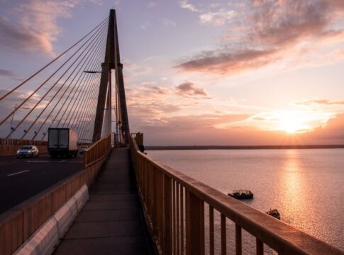
The Manaus Iranduba Bridge stands as a testament to both what’s possible and why it’s rarely attempted. Opened in October 2011 after seven years of construction, this cable-stayed bridge spans the Rio Negro tributary approximately 9 miles upstream from where it joins the main Amazon channel. The structure stretches 2.2 miles in total length, with its main span reaching 1,312 feet—making it one of the longest cable-stayed bridges in South America.
Construction costs exceeded $450 million, and the project faced numerous delays as workers contended with the river’s 50-foot annual water level fluctuations. Engineers designed bridge piers reaching depths of 160 feet, anchoring into bedrock beneath layers of sediment. The bridge deck sits 180 feet above typical water levels to accommodate river traffic and extreme flood conditions. Despite these engineering achievements, the Rio Negro tributary measures only a fraction of the main Amazon’s width and volume.
The bridge connected Manaus with three municipalities on the southern bank, improving access for approximately 100,000 residents and reducing ferry crossing times from hours to minutes. Yet this regional success story hasn’t spawned similar projects elsewhere along the Amazon system. The specific conditions—a relatively narrow tributary, major city proximity, and urban growth pressure—don’t exist at most potential crossing points along the river’s vast length.
Cultural Adaptation and River Transportation
Amazonian communities have developed sophisticated river-based transportation networks that render bridges less critical than in other regions. The region operates approximately 20,000 registered boats ranging from small wooden canoes to triple-decker passenger vessels carrying hundreds of travelers. These boats function as the region’s highways, with established routes connecting hundreds of riverside communities.
Ferry systems transport vehicles across the Amazon at strategic points, though these operations differ vastly from typical river ferries. The crossing near Óbidos can take several hours depending on conditions, and vehicles often wait days during peak periods. Yet local economies have adapted to these rhythms, with businesses and supply chains accounting for river-transit timelines. In cities like Santarém, located at the Amazon-Tapajós confluence, the waterfront bustles with cargo operations moving soybeans, timber, and consumer goods without requiring permanent bridges.
Indigenous and traditional communities, numbering over 400 distinct groups in the Amazon basin, maintain water-based lifestyles that predate modern infrastructure by millennia. These populations navigate the river’s complex network of channels, oxbow lakes, and seasonal waterways with expertise that GPS systems struggle to match. For these communities, the river is not an obstacle requiring bridges but rather a highway, food source, and cultural foundation simultaneously.
Environmental Considerations and Future Outlook
Bridge construction across the Amazon would trigger significant environmental consequences beyond the immediate construction footprint. The river’s floodplain ecosystems depend on seasonal inundation cycles that distribute nutrients, fish larvae, and sediments across vast areas. Bridge approaches would require elevated roadways or causeways extending miles through these sensitive wetlands, fragmenting wildlife corridors and altering water flow patterns.
The Amazon basin contains approximately 10% of Earth’s biodiversity, including thousands of fish species that migrate hundreds of miles along the river system. Marine biologists have documented fish traveling from the Amazon’s mouth near Belém to headwaters in the Andes—journeys exceeding 3,000 miles. Bridge piers and construction activities could disrupt these migrations, with cascading effects through aquatic food webs that support both wildlife and human communities dependent on fishing.
Climate change may eventually alter the bridge equation in unexpected ways. Research published by the Brazilian National Institute for Space Research indicates that deforestation and shifting rainfall patterns could reduce the Amazon’s flow by 20-30% by 2050. If these projections prove accurate, some sections might narrow sufficiently to make bridge construction more feasible—though at the catastrophic cost of degrading the world’s largest rainforest ecosystem.
Current infrastructure planning in Amazonian countries prioritizes river port improvements, airport expansions, and regional road networks over bridge megaprojects. Brazil’s 2021-2030 transportation plan allocates approximately $8 billion for Amazon region infrastructure, with funds directed toward navigability improvements and port modernization rather than new bridges. This approach reflects both economic pragmatism and growing environmental awareness about development impacts in sensitive ecosystems.
Frequently Asked Questions
Are there any plans to build bridges across the Amazon River?
While various proposals have been discussed over decades, no concrete plans currently exist for bridges across the main Amazon channel. The Brazilian government prioritizes river transport improvements and existing ferry operations over bridge construction due to cost, environmental concerns, and limited traffic demand in most regions.
How do vehicles and cargo cross the Amazon River today?
Vehicles cross via ferry services at strategic points, with major crossings operating near cities like Santarém and Óbidos. Most cargo travels by boat along the river itself rather than crossing it, as the Amazon functions as a natural highway connecting interior regions to Atlantic ports.
Could modern engineering technology make Amazon bridges possible?
Modern engineering could theoretically bridge the Amazon at significant cost, likely requiring floating bridge sections, cable-stayed designs, or suspension bridges with mile-long main spans. However, the economic justification remains weak given sparse population density on both banks and the river’s effective function as existing transportation infrastructure.
What is the widest point of the Amazon River?
During wet season, the Amazon’s width reaches approximately 30 miles at its widest points near the river’s mouth, though it varies dramatically throughout the year. Even at narrow points like Óbidos, the river maintains widths exceeding one mile year-round, making bridge construction extraordinarily expensive.
Key Takeaways
- The Amazon’s extreme width variations (6-30 miles), depths exceeding 300 feet, and sediment-laden waters create engineering challenges that make bridge construction economically impractical at most points.
- Sparse population distribution across the Amazon basin means insufficient traffic demand to justify multi-billion dollar bridge investments, unlike densely populated regions where bridges generate substantial economic returns.
- The region’s well-developed river transportation network effectively serves existing needs, with thousands of boats moving people and cargo along the Amazon’s natural channels rather than requiring crossings.
- The single major bridge near the Amazon system—the Manaus Iranduba Bridge over the Rio Negro tributary—required seven years and $450 million to construct, demonstrating both the technical feasibility and prohibitive costs of such projects.